Skip to primary navigation
Skip to main content
Skip to primary sidebar
Eight Point Wind
About
Project Benefits
Project Description and Location
Project Safety
Project Maps
News
Public Involvement
Public Involvement Plan
Article 10 Public Involvement Program Tracking Report
Stipulations
Publications and Educational Materials
Permitting
Article 10
Summary of Article 10 Intervenor Funding Process
Article 10 Supplement to the Application
Article 10 Second Supplement to the Application
Amendment to the Certificate
Preliminary Scoping Statement
Article VII
FAQ
FAQs about Wind Energy
FAQs about the Eight Point Wind Energy Center
Contact Us
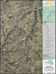
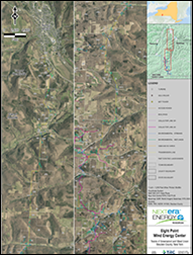
Project Maps
Eight Point Wind Final Layout Map
Eight Point Wind Final Layout Map (T-Line)
Copyright © 2022 Eight Point Wind Energy Center. All rights reserved
email: info@eightpointwind.com
Read our privacy policy
Visit the NextEra Energy Website